Do You Know the Difference Between El Niño and La Niña?
Get to know the “sibling” phenomena likely causing extreme weather near you

Recently, you may have heard about something called “El Niño.” But what exactly is El Niño and its sibling “La Niña”? Why do these terms seem to emerge from the depths of the scientific community and drop into popular vocabulary every few years? And how are they connected to extreme weather and our ocean?
What Are El Niño and La Niña?
El Niño and La Niña are part of a natural climate pattern in the tropical Pacific called the El Niño-Southern Oscillation, or ENSO. These two phases are different sides of the same coin, creating equally extreme shifts in temperature and air pressure.
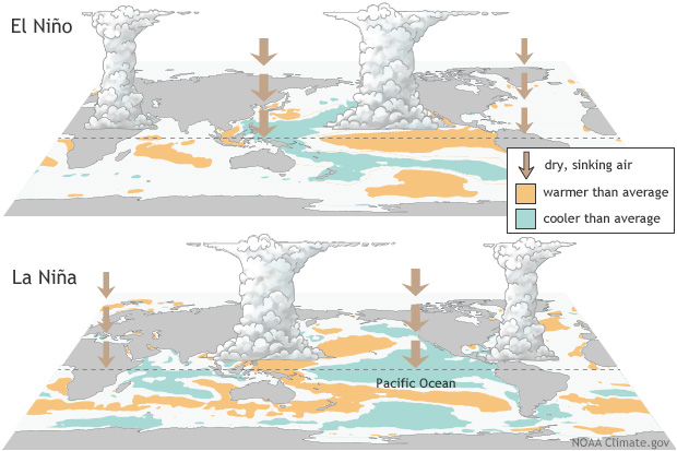
El Niño occurs when surface water in the equatorial Pacific becomes warmer than average and easterly winds weaken. La Niña is the opposite: cooler-than-normal sea surface temperatures and stronger easterly winds. ENSO cycles can last up to seven years. El Niño and La Niña significantly impact weather patterns in all corners of the globe, often leading to more extreme weather, storm frequency and intensity.
A strong El Niño can cause flooding in some regions and drought, heat waves and wildfires in others. It often causes crop losses, coral bleaching and marine die-offs due to unusually warm ocean temperatures. El Niño tends to suppress Atlantic hurricane activity, though it increases the risk of heavy precipitation and harm to fisheries elsewhere. In the Northern Hemisphere, El Niño typically builds between March and June, peaks in December, and weakens by February.
La Niña, by contrast, often fuels an active Atlantic hurricane season and increases tornado frequency across the southern United States. Like El Niño, it builds in spring and peaks around December.
Get Ocean Updates in Your Inbox
Sign up with your email and never miss an update.
Predicting ENSO
In 1923, the physicist Sir Gilbert Walker discovered the “Southern Oscillation,” or large-scale changes in sea level pressure across the tropical Pacific. However, it wasn’t until the late 1960s that the metorologist Jacob Bjerknes found that the changes in the ocean and the atmosphere were connected, and the hybrid term “ENSO” was born. In 1974, researchers at Oregon State University attempted to predict ENSO for the first time.
Modeling has greatly advanced since the early days. Today, scientists at the National Oceanic and Atmospheric Administration (NOAA) issue regular predictions about ENSO, which are now more accurate than ever.
NOAA gives a one-in-four chance that an El Niño could reach “very strong” intensity later in 2026, qualifying it as a “super El Niño.” This threshold has been crossed only a handful of times in recorded history, each triggering droughts, floods and record temperatures across multiple continents. NOAA’s data and models deliver life-saving early warning forecasts, like that of the predicted super El Niño, which allow communities to better prepare for and respond to extreme weather events.
Take Action
Every American, regardless of where they live, depends on NOAA’s scientists and professionals, whose work spans from the ocean floor to the far reaches of space. Unfortunately, NOAA is under threat. The Trump administration has proposed billions of dollars in cuts to the agency, which could weaken weather forecasting, disrupt fisheries management and stall critical ocean research, putting American lives and global scientific leadership at risk.
Ocean Conservancy is committed to working with NOAA to keep the public informed on climate and ocean science. We all benefit from a healthier ocean, and investing in research is the most effective way to restore ocean health and reduce the impact of severe weather events caused by El Niño and La Niña. Our ocean is not partisan, and protecting it requires all hands on deck and all sides of the aisle. Now, it’s more important than ever to demand that members of Congress prioritize our ocean. Add your name now.